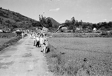
Seeing off the organizers

- Date
- Sept. 24, 1962
- Nov. 11, 2014
- Address
- 3-171 Nanpukuji, Minamata City


- People were seeing off the organizers. Roads have not been paved.
- The present scene around Tsuruta Crossing. The roads are paved and houses stand side by side in the area that used to be rice fields.
Reference sources
- The Edo Period:
The Picture Map of Ashikita-gun, Collection of Kumamoto Gakuen University Library, the late Edo Period. - The Meiji Period:
The Japanese National Atlas at the end of Edo Period and in the Meiji Period, Kashiwa Shobo, Collection of Kumamoto Gakuen University Library, 1983.