Minamata Konjyaku
In and around Minamata city at present, only Hyakken Outlet and the seawall barrier at Minamata Eco Park designed to keep organic mercury contained have any signs conveying the history of Minamata disease. A long time has passed since part of Minamata Bay has been reclaimed from the contaminated sewage of Chisso. Very few traces of the evidence of the Minamata disease incidents remain. Knowing and understanding such histories around these areas is indispensable to put the lessons of Minamata disease to good use. We created “Minamata now and then” to let you re-experience the changes in Minamata from the past till now.
In “Minamata Now and Then”, you can see the differences and changes in Minamata through a pictorial display of maps from the late Edo period through to maps from the Meiji era to present. The maps are held by Kumamoto Gakuen University and we have added current and historical photos and related historical information on a map of Minamata. All this helps you trace the local history of Minamata.
The pictures were selected from the approximately 600,000 pictures taken in 1960’s among the old archival documents in the Shin-Nihon Chisso Labor Union. You can identify some images of Minamata city, and see each site in the past and the present as well.
Search using the options below
-
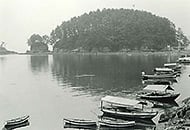
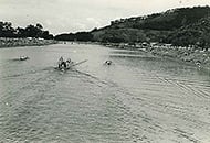
Fishing boats at Yunoko Hot Spr... -
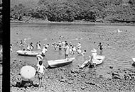
Swimming beach in Yunoko -
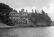
Sankaikan (Japanese inn) -
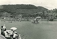
Traditional boat race -
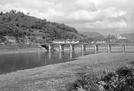
The mouth of Minamata-gawa River -
Around Saiwai-machi
Reference sources
- The Committee for the Compilation of History of Minamata City (Jun, 1996). History of Minamata City
- The Committee for the Compilation of History of Minamata City (Oct. 1991). New History of Minamata City, vol. 1
- The Committee for the Compilation of History of Minamata City (Oct. 1966). New History of Minamata City, vol. 2
- The Committee for the Compilation of History of Minamata City (Mar. 1997). New History of Minamata City: The Folk Customs and People
- Chisso Corporation (Sept. 2011). History of Chisso Corporation: one hundred weather-beaten years
- Masaru Mugishima (Dec. 2013). Yatsushio, Minamata and Ashikita Now and Then. Kyoudo Shuppansha. ISBN 87663
Search on the map
Reference sources
- The Edo Period:
The Picture Map of Ashikita-gun, Collection of Kumamoto Gakuen University Library, the late Edo Period. - The Japanese National Atlas at the end of Edo Period and in the Meiji Period, Kashiwa Shobo, Collection of Kumamoto Gakuen University Library, 1983.